The best wall maps for classrooms turn geography lessons into an always-visible reference point. The right choice depends on available wall space, map detail, durability, and whether students need a world view, U.S. coverage, or both.
We compared 10 classroom-friendly options, including oversized world maps, laminated map sets, educational posters, and designs with flags, capitals, or topographical detail.
Best 10 Wall Maps for Classrooms Picks for 2026
Classic Global Reference
Rand McNally Africa-Centered World Map

- Africa-centered projection keeps countries intact
- Laminated and dry-erase-marker resistant
- Topographical relief with antique-style accents
Best For: Durable classroom and office reference maps
Maximum Classroom Visibility

- Extra-large 46 x 80-inch single sheet
- Write on it with whiteboard pen and wipe clean
- Colored political map with cities and shading
Best For: Large classrooms and interactive geography lessons
Two-Map Teaching Set
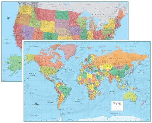
- Includes matching USA and world maps
- Each map measures 32 x 50 inches
- Rolled 80-pound poster paper format
Best For: Comparative U.S. and world geography instruction
Kid-Friendly Geography Tool
World Map with Flags and Capitals
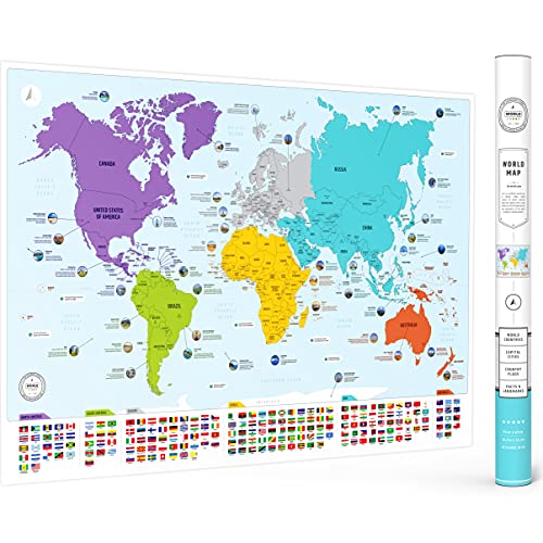
- Shows countries, flags, and capitals
- Color-coded continents support easy learning
- Includes 50 interesting world facts
Best For: Elementary classrooms and homeschool geography
Best Overall Set
Laminated World and USA Map Duo

- Two-map world and USA set
- Large 24-by-36-inch format
- Laminated for dry-erase use
Best For: Classrooms needing a coordinated pair of large geography maps
Best for Young Learners
Kids’ USA and World Map Posters

- Designed for preschool-age learners
- Waterproof, tear-resistant PVC
- Dry-erase compatible surface
Best For: Preschools, daycares, and early geography activities
Best Large-Format Option

- Large 32-by-50-inch display
- Eight-color political map design
- Double-sided dry-erase lamination
Best For: Whole-class viewing in spacious classrooms
Best Classroom Map Set
Laminated World and USA Map Pair

- Includes world and USA posters
- Equal Earth relative-size design
- 3 MIL laminated and tear resistant
Best For: Compact classroom geography displays
Best Oversized Classroom World Map

- Large 36 x 48 inch display
- Miller Projection reduces polar distortion
- UV laminated for dry-erase use
Best For: Large-room world geography instruction
Best Made-in-USA Classroom Map Pair
Laminated World and US Posters

- Includes world and USA maps
- 18 x 29 inch posters
- 3 MIL laminated and tear resistant
Best For: Everyday classroom geography reference
Classic Global Reference – Rand McNally Africa-Centered World Map
For classrooms that need a durable reference with a more polished look, this Rand McNally map combines current political information with color-matched topographical relief. Its Africa-centered projection keeps every continent and country intact, making it a distinctive option among wall maps for classrooms.
Best For: Classrooms, offices, and homes seeking a laminated world reference with decorative styling.
Pros:
- Africa-centered projection shows continents and countries complete without the usual map splits.
- Laminated surface resists scuffs, fingerprints, and dry-erase marker.
- Topographical relief highlights major mountain ranges, plateaus, and basins.
- Ships rolled in a sturdy tube to help prevent creases.
Cons:
- At 50 x 32 inches, it requires substantial wall space.
- Antique-style accents may be less suitable for classrooms wanting a brightly colored children’s design.
This is a strong choice when visual accuracy, durability, and presentation matter equally. The laminated finish supports frequent handling, while the projection offers a useful alternative for lessons involving geography, scale, trade, or migration.
Maximum Classroom Visibility – Giant 46 x 80-Inch World Map
When visibility from across the room is the priority, this 46 x 80-inch Mega-Map makes a dramatic classroom display. It combines a large 1:20m scale with colored countries, towns, cities, hill shading, and a laminated write-on surface.
Best For: Large classrooms and group instruction where students need to see map details from a distance.
Pros:
- Extra-large single-sheet format provides exceptional wall coverage.
- Laminated surface can be marked with whiteboard pen and wiped clean.
- Includes political detail, cities, towns, hill shading, and sea shading.
- Ships rolled in a tube for crease-less delivery.
Cons:
- The 46 x 80-inch size needs a very large, unobstructed wall.
- Its size may make installation and repositioning less convenient.
This is the most practical pick for teaching from the front of a sizable room. The write-on finish adds flexibility for labeling exercises and temporary lesson notes, provided the available wall can accommodate its unusually wide format.
Two-Map Teaching Set – Classic USA and World Maps
This two-map set gives a classroom both global and national coverage in matching 32 x 50-inch formats. The current USA and world maps use an antique-style presentation and arrive rolled on 80-pound poster paper rather than folded.
Best For: Classrooms or offices that want coordinated United States and world wall maps for comparative geography lessons.
Pros:
- Includes both a world map and a United States map.
- Generous 32 x 50-inch size for each map.
- Rolled, unfolded format avoids the creases associated with folded maps.
- Antique look works as both classroom decor and a reference display.
Cons:
- Printed on poster paper rather than a laminated surface.
- Two large maps require considerable wall space.
- The supplied notes do not specify a write-on finish.
Choose this set if your curriculum moves regularly between world geography and U.S. geography. It offers broad coverage and a coordinated appearance, though classrooms needing heavy-duty wipe-clean durability may prefer a laminated alternative.
Kid-Friendly Geography Tool – World Map with Flags and Capitals
For younger learners and homeschool spaces, this colorful 26 x 38-inch map emphasizes accessible geography facts over formal cartographic styling. It identifies countries, flags, capitals, and color-coded continents, and adds 50 interesting facts for extra learning prompts.
Best For: Elementary classrooms, homeschool rooms, children’s spaces, and introductory geography activities.
Pros:
- Displays countries, flags, and capitals in an education-focused layout.
- Color-coded continents make broad regional comparisons easier.
- Includes 50 interesting facts to encourage discussion and exploration.
- Matte paper finish and protective tube support display and framing.
Cons:
- Paper construction is less suited to frequent wiping or heavy handling than laminated maps.
- At 26 x 38 inches, it is smaller than the other listed classroom maps.
- The supplied notes do not indicate a dry-erase or write-on surface.
This is an approachable choice when the goal is to make geography inviting for children. Its flags, capitals, continent colors, and fact-based design provide built-in conversation starters, while the matte finish keeps it suitable for framing or straightforward wall display.
Best Overall Set – Laminated World and USA Map Duo
For shoppers comparing wall maps for classrooms, this two-piece set combines a 24-by-36-inch world map with a matching USA map. Its laminated, coated finish supports dry-erase use, while the political and topographic details provide a broad geography reference for lessons or display.
Best For: Classrooms, offices, homes, and educational spaces needing both world and U.S. maps in a large matching set.
Pros:
- Includes both world and USA maps.
- Large 24-by-36-inch format offers substantial wall coverage.
- Laminated surface is designed for dry-erase use.
- Uses 3D visual terrain relief and up-to-date map details.
Cons:
- Both maps use the same large 24-by-36-inch size, which may require considerable wall space.
- The maps are unframed, so mounting hardware or a display solution may be needed.
This is a practical choice when a classroom needs a coordinated world-and-USA reference set rather than a single map. The dry-erase lamination adds flexibility for interactive instruction.
Best for Young Learners – Kids’ USA and World Map Posters
Among wall maps for classrooms, this two-poster set is tailored to preschool and early-learning environments. Bright colors, clear labeling, artist-drawn icons, and a waterproof PVC construction make the maps approachable for young students and suitable for repeated interactive use.
Best For: Preschools, daycares, playrooms, and homeschool settings introducing toddlers and early learners to continents, countries, and U.S. states.
Pros:
- Includes separate USA and world map posters.
- Bright illustrations and artist-drawn icons support visual learning.
- Waterproof, tear-resistant PVC material is made for long-term use.
- Can be written on with dry-erase markers and wiped clean.
Cons:
- The 24-by-16-inch size is smaller than many large classroom wall maps.
- The unframed posters may need separate mounting supplies.
- The colorful, early-learning design may be less suitable for advanced geography instruction.
This set emphasizes accessibility and interaction over maximum map scale. It is a strong fit for younger learners who benefit from simple layouts, vivid visuals, and repeatable dry-erase activities.
Best Large-Format Option – Swiftmaps Signature World Map
Swiftmaps 32" x 50" RMC Large World Wall Map Poster - Laminated Rolled (32x50 Signature World)
Check Price On AmazonFor classrooms that want a single statement map, this 32-by-50-inch Swiftmaps poster provides expansive coverage and detailed political information. Its eight-color design, 3D terrain relief, and blue-shaded oceans are paired with a durable 3-mil double-sided dry-erase lamination.
Best For: Classrooms, offices, boardrooms, and other spaces with enough wall area for one large world map.
Pros:
- Extra-large 32-by-50-inch format is easy to view across a room.
- Includes vivid eight-color cartography and 3D visual terrain relief.
- Politically updated with current cities and country boundaries, according to the supplied description.
- Heavy 36lb poster paper has durable 3-mil double-sided dry-erase lamination.
Cons:
- It is a world-only map, so a separate USA map would be needed for U.S.-focused instruction.
- The very large dimensions require substantial wall space.
- It is supplied rolled, which may require care during installation.
This map is best when visibility and visual impact matter more than having a multi-map set. The large format and laminated dry-erase surface support whole-class viewing and interactive geography lessons.
Best Classroom Map Set – Laminated World and USA Map Pair
This two-poster set is a practical choice for classrooms that need both global and U.S. reference material. The wall maps for classrooms measure 18 by 29 inches each and use a true-relative-size Equal Earth world map design.
Best For: Classrooms seeking a compact world-and-USA map set for everyday visual reference.
Pros:
- Includes one world map and one USA map.
- Equal Earth design shows continents at their true relative size.
- 3 MIL lamination adds durability and tear resistance.
- Each poster measures 18 by 29 inches.
Cons:
- The posters are smaller than oversized classroom wall maps.
- The supplied details do not specify dry-erase compatibility.
This set offers broad geographic coverage in a manageable format. Its laminated, tear-resistant finish makes it suitable for regular classroom display, while the two-map format supports both world and U.S. geography lessons.
Best Oversized Classroom World Map – Classic Elite Laminated Map
For classrooms needing a large central display, this 36-by-48-inch world map provides an oversized format with richly colored classic styling and detailed cartography. Its UV-laminated surface is designed to stay flat and can be used with dry-erase markers.
Best For: Large classrooms, geography centers, and lessons that benefit from an oversized world map.
Pros:
- Large 36 by 48 inch format is easy to view from across a room.
- Classic-style design includes flags of the world and detailed cartography.
- Miller Projection reduces distortion near the poles.
- Two-sided UV coating supports durability and dry-erase use.
Cons:
- Dry-erase markers are recommended for the gloss-coated laminate.
- It is a single world map rather than a combined world-and-USA set.
This is the strongest option here for a prominent classroom wall map. The extra-large dimensions improve visibility, while the UV coating supports repeated write-on and wipe-off activities without relying on a traditional heavy film laminate.
Best Made-in-USA Classroom Map Pair – Laminated World and US Posters
This laminated poster set gives classrooms two separate geographic references in a consistent 18-by-29-inch format. It includes a world map and a United States map, with 3 MIL lamination intended to improve durability and tear resistance.
Best For: Teachers who want a straightforward, made-in-USA world-and-U.S. poster set.
Pros:
- Includes two posters: one world map and one USA map.
- Each poster measures 18 inches tall by 29 inches wide.
- High-quality 3 MIL lamination adds durability.
- Tear-resistant construction suits regular classroom display.
Cons:
- The 18-by-29-inch size may be modest for viewing across a large room.
- The supplied details do not indicate dry-erase compatibility.
This set is a balanced pick when a classroom needs both world and U.S. coverage without moving to an oversized wall chart. Its coated, laminated finish should help the posters hold up better than unlaminated paper during routine use.
How We Picked the Best Wall Maps for Classrooms
We focused on practical classroom performance rather than appearance alone. Our selections represent a range of sizes, formats, map styles, and price points so teachers can match a map to the age of their students and the available wall space.
Key considerations included readability from across a room, durability, educational labeling, mounting flexibility, and whether the map offers useful context such as capitals, flags, elevation, borders, or proportional landmass. Laminated options received particular attention because they are easier to wipe clean and generally better suited to frequent handling.
Quick Comparison
- Best for traditional detail: Classic-style world maps with labeled countries, borders, and topographical shading.
- Best for large classrooms: Oversized maps measuring roughly 46 by 80 inches, offering strong visibility from the back of the room.
- Best for teaching both scales: World-and-U.S. map sets that support global geography and domestic lessons.
- Best for younger students: Colorful posters featuring flags, capitals, and simplified educational graphics.
- Best for durability: Laminated posters and map sets that resist light moisture, fingerprints, and everyday classroom wear.
Key Buying Factors for Wall Maps for Classrooms
Size and Viewing Distance
A 24-by-36-inch map can work well in a small classroom, reading corner, or home learning area. Larger 32-by-50-inch and 36-by-48-inch maps are easier to read during group instruction. Oversized maps create the strongest visual impact but require a large, unobstructed wall.
Map Content and Projection
Check whether the map emphasizes political borders, physical geography, flags, capitals, or proportional land area. Standard classroom maps may use projections that enlarge some regions, while Equal Earth-style designs provide a more balanced visual comparison of continents.
Lamination and Mounting
Lamination is useful when students will point to locations, use removable markers, or handle the map regularly. Confirm whether the product arrives rolled or folded, and allow rolled maps time to flatten before mounting. Use suitable poster rails, adhesive strips, or a frame based on the wall surface.
World Map, U.S. Map, or a Set
A world map is the most versatile choice for geography and social studies. A two-map set offers better coverage when lessons move between global and U.S. geography, but it needs more wall area and may cost more than a single poster.
Who Should Buy Which Wall Maps for Classrooms?
Choose a classic laminated world map if you want a durable, general-purpose reference for older students. Select an oversized map when visibility from a distance matters most. For elementary classrooms, colorful maps with flags and capitals can make independent exploration easier. If your curriculum covers both domestic and international geography, a laminated world-and-U.S. set is usually the most practical choice. Buyers prioritizing accurate visual comparisons should consider a map using an equal-area projection.