The best wall maps for children turn geography into something visible, engaging, and easy to revisit every day. This roundup compares 10 options for bedrooms, playrooms, homeschool spaces, and classrooms.
We looked at map coverage, child-friendly design, durability, display format, and educational detail so you can choose a practical map for your space and the child using it.
Best 10 Wall Maps for Children Picks for 2026
Durable Duo

- Two-poster USA and world map set
- 18-by-29-inch posters
- 3 MIL laminated and tear resistant
Best For: Durable home learning displays
Illustrated Explorer

- Simple, informative world map
- Colorful illustrations about animals and foods
- Large folded 36.25-by-24.25-inch poster
Best For: Visual world-learning displays
Interactive Classroom Set

- Two 24-by-16-inch educational posters
- Waterproof, tear-resistant PVC
- Dry-erase compatible for interactive lessons
Best For: Preschool classrooms and homeschool spaces
True-Scale Learning Pair
Equal Earth World and USA Maps

- USA and world map two-pack
- Equal Earth design shows relative continent size
- 18-by-29-inch laminated, tear-resistant posters
Best For: Home geography displays focused on map accuracy
Illustrated Learning Pick
Kids' Illustrated World Wall Map

- Color-coded continents with plants, animals, and landmarks
- Labels capitals, cities, and bodies of water
- Large 50-by-32-inch heavy-paper format
Best For: Bedrooms, playrooms, and classrooms
Two-Map Reference Set
Laminated World & US Map Posters

- Includes separate world and U.S. posters
- Each map measures 18 by 29 inches
- 3 MIL laminated and tear resistant
Best For: Compact home or classroom reference
Interactive Decor Pick
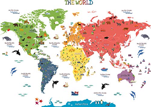
- Shows countries, flags, animals, and landmarks
- Covers seven continents and five oceans
- Removable, repositionable, and waterproof film
Best For: Playrooms, nurseries, and smooth classroom walls
Best Laminated Set

- Two-poster world and USA map set
- 18-by-29-inch posters
- 3 MIL laminated and tear resistant
Best For: Durable home, homeschool, or classroom displays
Best Animal-Themed Option
Animal World Map Wall Stickers

- Animal-focused world map design
- Sticker format for wall display
- Listed size is 12.4 by 16.14 inches
Best For: Decorative kids’ bedrooms and play areas
Best for Geography Study
World Map with Flags & Capitals
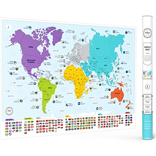
- Shows countries, flags, and capitals
- Includes 50 world facts
- Large 26-by-38-inch matte poster
Best For: Classrooms, homeschool, and detailed geography learning
Durable Duo – Laminated USA and World Maps
This two-poster set is a practical choice if you want wall maps for children covering both U.S. geography and the wider world. Each 18-by-29-inch poster has 3 MIL lamination for added durability and tear resistance.
Best For: Kids’ bedrooms, playrooms, and home learning spaces that need both USA and world map coverage.
Pros:
- Includes both a USA map and a blue-ocean world map.
- Large 18-by-29-inch format provides useful wall display space.
- 3 MIL lamination helps protect the posters from tears and everyday wear.
Cons:
- The supplied details do not specify the map’s labeling style or geographic features.
- Both posters use the same listed dimensions, which may require substantial wall space.
Choose this set when durability and two-map coverage matter more than specialized design details. Its laminated finish makes it a straightforward option for frequently used children’s learning areas.
Illustrated Explorer – Collins Children's World Map
This large Collins poster is a strong pick among wall maps for children who learn through colorful visuals. Its simple world map uses familiar illustrations and facts about topics such as animals and foods, with a 36.25-by-24.25-inch display format.
Best For: Children’s bedrooms, classrooms, or offices where a large educational world poster can remain on display.
Pros:
- Familiar illustrations are designed to make facts memorable.
- Large 36.25-by-24.25-inch size is well suited to wall display.
- Printed on thick paper and shipped in a cardboard-backed envelope.
- Produced by Collins, a publisher with a long educational publishing history.
Cons:
- It is a single world map rather than a USA-and-world set.
- The poster is folded for shipping, so creases may be present initially.
- The supplied details do not indicate lamination or waterproofing.
This map emphasizes approachable illustrations and a generous poster size rather than protective finishing. It is a good fit when visual discovery and display presence are the main priorities.
Interactive Classroom Set – USA and World Map Posters
This two-piece set offers practical wall maps for children in preschool classrooms, playrooms, and homeschool spaces. The 24-by-16-inch USA and world posters use bright illustrations, clear labeling, and waterproof PVC plastic that can be written on with dry-erase markers.
Best For: Toddlers and early learners ages 1-5, especially in classrooms or learning areas that benefit from reusable visual activities.
Pros:
- Includes both USA and world map posters for broad geography coverage.
- Waterproof, tear-resistant PVC material is designed for long-term use.
- Dry-erase compatibility supports interactive lessons and repeated practice.
- Bright colors and artist-drawn icons are intended to support visual learning.
Cons:
- The 24-by-16-inch posters are smaller than some large wall-map formats.
- The supplied details do not include frames.
- Its toddler-focused visual approach may be less suited to advanced geography study.
For younger children, the reusable plastic construction is the standout feature. This set is especially practical where maps will be handled, marked, wiped clean, and used repeatedly.
True-Scale Learning Pair – Equal Earth World and USA Maps
This two-poster option is worth considering when accurate visual proportions are important in wall maps for children. It pairs a laminated world map using an Equal Earth design, which shows continents at true relative size, with an 18-by-29-inch U.S. map.
Best For: Home geography displays that introduce children to both global and U.S. maps while emphasizing continent size relationships.
Pros:
- Includes one world map and one USA map.
- Equal Earth world map design shows continents at true relative size.
- 18-by-29-inch posters provide a substantial display format.
- 3 MIL lamination and tear resistance support durability.
Cons:
- The supplied details do not specify illustrations or child-focused icons.
- Both posters require more wall space than compact map prints.
- The notes do not clarify whether the same laminated finish applies identically to both maps.
This set stands out for combining kid-friendly wall display with a world-map projection designed to preserve relative continent size. It is a sensible choice for families seeking a more geographically proportioned presentation.
Illustrated Learning Pick – Kids' Illustrated World Wall Map
If you want wall maps for children that feel both educational and decorative, this Rand McNally option is a strong choice. Its colorful, illustrated design introduces geography alongside plants, animals, landmarks, cultural icons, and more, while labeled capitals, cities, and bodies of water add useful reference points.
Best For: Children’s bedrooms, playrooms, and classrooms where a large, engaging world map can support casual learning.
Pros:
- Color-coded continents and playful illustrations encourage exploration.
- Includes capitals, major cities, and bodies of water.
- Large 50-by-32-inch format with an elegant white border.
- Printed on heavy paper and suitable for framing.
Cons:
- The paper format may need framing or careful handling for long-term display.
- It covers the world rather than including a separate detailed U.S. map.
This is a particularly appealing pick when visual style matters as much as basic geography content. The combination of large dimensions, approachable illustrations, and broad subject coverage makes it a versatile learning accent.
Two-Map Reference Set – Laminated World & US Map Posters
For shoppers seeking wall maps for children with both global and national coverage, this two-poster set offers a practical setup. It includes one world map and one United States map, each measuring 18 by 29 inches, with lamination intended to improve durability and tear resistance.
Best For: Families or classrooms that want separate world and U.S. reference maps in a compact, easy-to-display format.
Pros:
- Includes both a world map and a United States map.
- Each poster measures 18 by 29 inches.
- 3 MIL lamination adds durability.
- Tear-resistant construction is practical for repeated reference.
Cons:
- The 18-by-29-inch size provides less display area than a large single world map.
- The supplied notes do not specify child-focused illustrations or educational themes.
This set prioritizes straightforward reference value and protection over playful presentation. It is a sensible option when having two distinct maps matters more than choosing a decorative, illustrated design.
Interactive Decor Pick – Peel & Stick World Map Decals
These peel-and-stick decals are a flexible alternative to traditional wall maps for children. The design combines countries, flags, animals, continents, oceans, landmarks, and buildings across two 40-by-12-inch sheets, creating an approachable learning display for a playroom, nursery, or classroom.
Best For: Young children and families who want a colorful, removable map display for a smooth wall or other clean, dry surface.
Pros:
- Features countries, flags, animals, landmarks, and buildings.
- Introduces seven continents and five oceans.
- Peel-and-stick application is removable and repositionable without residue, according to the supplied notes.
- Waterproof transparent film works on smooth, clean, dry surfaces.
Cons:
- Assembly is required using two sheets and precut elements.
- The product is intended for indoor use and smooth surfaces.
- The notes describe the decals as single-use despite their removable and repositionable design.
This option works well when you want educational wall art without committing to a framed poster. Its animal-focused visuals and removable application make it especially suitable for changing children’s spaces.
Best Laminated Set – Illustrated World & USA Maps
2 Pack - World & USA Map for Kids [Illustrated] - 2 Poster Set (LAMINATED, 18" x 29")
Check Price On AmazonFor families seeking durable wall maps for children, this two-poster set combines an illustrated world map with a USA map. Each 18-by-29-inch poster has a coated finish and 3 MIL lamination, making it a practical choice for everyday educational display.
Best For: Kids’ rooms, homeschool spaces, or classrooms that need both global and U.S. geography in one set.
Pros:
- Includes two posters: world and USA maps.
- Large 18-by-29-inch format provides useful viewing space.
- 3 MIL lamination adds durability and tear resistance.
- Coated paper finish is suitable for wall display.
Cons:
- The supplied details do not specify mounting hardware or adhesive.
- Both posters require separate wall space.
This set is a sensible pick when durability and map variety matter more than having a single oversized map. The laminated construction should help it hold up in child-focused learning areas.
Best Animal-Themed Option – Animal World Map Wall Stickers
These animal world map wall stickers offer a more decorative approach to wall maps for children. The sticker format can suit kids’ spaces where an animal-themed geography display is preferred over a conventional paper poster.
Best For: Children’s bedrooms or play areas that need an animal-focused world map wall decoration.
Pros:
- Animal world map design is tailored to children’s spaces.
- Wall-sticker format provides an alternative to framed posters.
- Lightweight package weighs 6 ounces.
Cons:
- The supplied details do not list lamination or tear resistance.
- The product dimensions are listed as 12.4 by 16.14 inches, smaller than several poster-style options.
- The notes do not specify the sticker material or installation method.
Choose this option primarily for its child-friendly animal theme and sticker format. Buyers seeking detailed specifications about durability or application should verify those details before ordering.
Best for Geography Study – World Map with Flags & Capitals
For a more information-rich choice among wall maps for children, this 26-by-38-inch world map combines countries, flags, capitals, color-coded continents, and 50 world facts. Its matte paper finish and vibrant full-color design work well as both an educational reference and room decor.
Best For: Classrooms, homeschool areas, children’s rooms, and families wanting a detailed geography reference.
Pros:
- Includes countries, flags, and capitals.
- Color-coded continents support visual learning.
- Features 50 interesting world facts.
- Large 26-by-38-inch size with a matte finish and protective tube shipping.
Cons:
- It is a single paper poster rather than a laminated map.
- The large format may require more wall space and suitable framing or mounting.
- The supplied notes do not mention included mounting hardware.
This is the strongest fit for active geography learning because it packs substantial reference content into a large display. Its matte paper is attractive and readable, though buyers wanting extra resistance to handling may prefer a laminated alternative.
How We Picked the Best Wall Maps for Children
We focused on products that support everyday geography learning rather than maps chosen only for decoration. The selection includes world maps, United States maps, two-map sets, illustrated designs, classroom posters, and removable wall decals.
Our main considerations were geographic coverage, readability, visual appeal, construction, and installation. Laminated posters are generally better suited to children’s rooms and classrooms because they resist small spills and can be wiped clean. Paper maps can be lighter and less expensive, but they may need a frame or careful mounting. Decals offer a flexible alternative when you want a large display without a traditional poster.
Quick Comparison
- Best for broad coverage: A world-and-USA map set gives children both global and national context.
- Best for durability: Laminated posters are easier to clean and better for high-use areas.
- Best for young children: Illustrated maps with animals, landmarks, or bright colors can make exploration more approachable.
- Best for classrooms: Large posters with clear labels, capitals, flags, and educational charts are easier to reference during lessons.
- Best for flexible decorating: Peel-and-stick decals work well when a framed or pinned poster is impractical.
Key Buying Factors for Wall Maps for Children
Map Detail and Readability
Check whether the map emphasizes countries, states, capitals, flags, landmarks, animals, or basic continental geography. More detail is not always better for younger children; labels should remain legible from the distance at which the map will be viewed.
Size and Available Wall Space
Measure the wall before ordering, including the space needed around furniture and doorways. Common poster sizes can look very different once mounted, while large decals may cover a broader area than expected.
Material and Mounting
Lamination helps protect against fingerprints and accidental moisture. Rolled posters may lie flatter than folded ones, while folded maps can be easier to ship and store. Confirm whether adhesive, hanging rails, frames, or poster strips are included.
Design and Age Suitability
Choose an illustrated style for visual discovery, a clean political map for reference, or a combination of both. Also check color contrast and label size if the map will be used by early readers or children with visual needs.
Who Should Buy Which Wall Maps for Children?
Parents furnishing a bedroom or playroom may prefer a laminated two-map set because it provides variety without requiring multiple purchases. For younger children, an animal-themed or illustrated map can encourage questions and independent exploration.
Homeschool families and teachers should prioritize readable labels, capitals, flags, and durable surfaces that can withstand frequent pointing and discussion. A large classroom poster or educational chart is usually the most practical choice.
If you rent, frequently redecorate, or have limited wall space, peel-and-stick decals provide a less permanent display. For a more traditional study area, choose a rolled or laminated poster and mount it with removable strips or a frame. Before buying, match the map’s level of detail, dimensions, and material to the child’s age, the room, and how actively the display will be used.