The right wall map can turn geography from a memorization exercise into an everyday visual lesson. These 10 wall maps for homeschool include practical laminated sets, colorful children’s designs, write-on surfaces, and display-worthy options for different ages and room sizes.
Whether you need a world-and-U.S. combination, a map with capitals and flags, or a durable poster for repeated lessons, this roundup highlights the features that matter most for home learning.
Best 10 Wall Maps for Homeschool Picks for 2026
Best All-Around Set
Classic Laminated World & USA Maps

- Two-map World and USA set
- Large 24-by-36-inch format
- Laminated for dry-erase use
Best For: General homeschool geography lessons
Best Decorative Option

- 20-by-30-inch linen banner
- Labels U.S. states
- Includes two metal hanging eyelets
Best For: Boho-themed homeschool rooms and playrooms
Best Compact Laminated Pair

- Includes world and USA posters
- 18-by-29-inch map size
- 3 MIL laminated and tear resistant
Best For: Smaller homeschool walls and durable reference use
Best for Young Learners
Interactive Kids’ Map Poster Set

- World and USA two-poster set
- Waterproof, tear-resistant PVC
- Dry-erase compatible for activities
Best For: Preschool and early-elementary geography learning
Best Overall

- Africa-centered projection keeps countries intact
- Laminated and dry-erase-marker resistant
- Shows topographical relief in a 50 x 32-inch format
Best For: Durable, reference-focused homeschool geography lessons
Best Map Pair

- Includes world and United States maps
- 3 mil laminated and tear-resistant
- Each poster measures 18 x 29 inches
Best For: Side-by-side world and U.S. geography lessons
Best for Kids
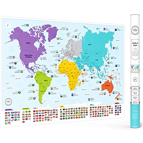
- Shows countries, flags, and capitals
- Color-coded continents aid visual learning
- Includes 50 interesting world facts
Best For: Kid-friendly introductory geography and homeschool decor
Best Compact U.S. Study Aid
Laminated United States Map Poster

- Double-sided and dry-erase compatible
- Waterproof and tear resistant
- Compact 17 x 23-inch format
Best For: Elementary geography lessons and smaller homeschool spaces
Best Large Interactive Bundle
Illustrated World and USA Maps
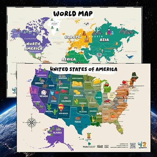
- Includes world and U.S. maps
- Large 24 x 36-inch display size
- Write-on, wipe-off laminated surface
Best For: Classrooms and homeschool rooms with ample wall space
Best Multi-Subject Set
World, USA, and Solar System Posters

- Three posters cover geography and astronomy
- Double-sided laminated and dry erasable
- Includes flags, insets, and fun facts
Best For: Compact homeschool learning centers with varied subjects
Best All-Around Set – Classic Laminated World & USA Maps
For shoppers comparing wall maps for homeschool, this two-map set provides both global and U.S. geography in a large 24-by-36-inch format. The laminated, coated finish supports dry-erase activities, while the 3D visual terrain relief adds a topographic element to geography lessons.
Best For: Homeschool rooms that need large, reusable world and United States maps for general geography instruction.
Pros:
- Includes both World and USA maps in one set.
- Large 24-by-36-inch size offers strong wall visibility.
- Laminated surface can be used with dry-erase markers.
- Combines political and topographic map details with 3D terrain relief.
Cons:
- The large poster size may require substantial wall space.
- The notes do not specify included mounting hardware or framing.
Choose this set when durability, scale, and broad geographic coverage matter more than a child-focused illustration style. Its reusable laminated surface is especially useful for repeated labeling and review.
Best Decorative Option – Boho United States Map Banner
This banner is a practical choice for wall maps for homeschool when the learning space also needs coordinated decor. Its 20-by-30-inch linen design labels U.S. states in a soft boho palette, making it suitable for a homeschool room, playroom, or reading corner.
Best For: Homeschool spaces that want a lightweight, child-friendly United States map with decorative appeal.
Pros:
- Displays U.S. state names for introductory geography practice.
- Soft boho colors and linen texture suit rooms with decorative themes.
- Two metal eyelets provide simple wall, door, or bulletin-board hanging.
- Fade-resistant fabric is designed for everyday indoor use.
Cons:
- Covers the United States only, not world geography.
- It may need light ironing after unpacking to remove creases.
- The banner is not flame-retardant and should be kept away from heat and open flames.
This banner works best as an approachable visual reference and room accent rather than a comprehensive map set. Its fabric construction and hanging eyelets make it easy to place in a flexible learning area.
Best Compact Laminated Pair – Equal Earth World & USA Maps
For homeschoolers seeking wall maps for homeschool in a more compact format, this two-poster set measures 18 by 29 inches per map. Both posters have 3 MIL lamination for added durability and tear resistance, and the Equal Earth world map design presents continents at true relative size.
Best For: Homeschool areas with moderate wall space that need a durable world-and-U.S. map combination.
Pros:
- Includes one world map and one USA map.
- Equal Earth design shows continents at true relative size.
- 3 MIL lamination helps improve durability and tear resistance.
- Smaller 18-by-29-inch dimensions fit more limited wall areas.
Cons:
- The set is smaller than 24-by-36-inch alternatives.
- The supplied notes do not indicate whether the maps are dry-erase compatible.
This is a sensible middle ground for families wanting two durable reference posters without committing to oversized wall art. The Equal Earth projection is a notable feature for conversations about relative continent size.
Best for Young Learners – Interactive Kids’ Map Poster Set
Families looking for wall maps for homeschool for toddlers and early learners may prefer this colorful two-poster set. It pairs a USA map with a world map, uses artist-drawn icons and clear labeling, and is made from waterproof, tear-resistant PVC that can be written on with dry-erase markers.
Best For: Preschool and early-elementary homeschool lessons focused on visual geography, repetition, and interactive practice.
Pros:
- Includes both USA and world maps for broad introductory coverage.
- Bright illustrations and artist-drawn icons support visual learning.
- Waterproof, tear-resistant PVC construction is designed for long-term use.
- Dry-erase compatibility enables reusable interactive lessons.
Cons:
- At 24 by 16 inches, each poster is relatively compact.
- The colorful early-learning design may be less suited to advanced geography study.
- The posters are unframed.
This set is strongest when maps are part of hands-on early learning rather than passive wall decoration. Its wipe-clean material and child-oriented visuals make it convenient for repeated homeschool activities.
Best Overall – Classic World Wall Map
For homeschoolers who want a durable reference map with a polished look, this Rand McNally option combines current political information with physical geography. Its Africa-centered projection keeps continents and countries intact, while lamination makes it practical for repeated classroom use.
Best For: Homeschool rooms that need a large, durable world reference for geography, trade routes, migration, and physical features.
Pros:
- Africa-centered projection shows every continent and country complete.
- Color-matched topographical relief highlights mountains, plateaus, and basins.
- Laminated surface resists scuffs, fingerprints, and dry-erase marker.
- Large 50 x 32-inch format with antique-style accents.
Cons:
- The large size may require substantial wall space.
- Its decorative styling may not suit learners who prefer a brightly illustrated kids’ map.
This is the strongest choice for families prioritizing map accuracy, physical geography, and long-term durability. The rolled, laminated construction also helps it arrive crease-free and ready to hang.
Best Map Pair – Laminated World & US Map Set
This two-poster set is a practical pick for homeschoolers who want both global and United States geography in one purchase. Each 18 x 29-inch map is updated, tear-resistant, and protected by 3 mil lamination for everyday handling.
Best For: Homeschool spaces that need separate world and U.S. maps for side-by-side geography lessons.
Pros:
- Includes both a world map and a United States map.
- 3 mil lamination adds durability and tear resistance.
- 18 x 29-inch size fits more modest wall areas.
- Made in the USA.
Cons:
- The supplied notes provide fewer educational details than the other maps.
- Two posters require space for separate display or storage.
Choose this set when curriculum coverage matters more than decorative presentation. Having world and U.S. references together can make it easier to connect national and global geography topics.
Best for Kids – Flags & Capitals World Map
For younger learners, this colorful educational map makes wall-based geography more engaging. It identifies countries, flags, and capitals, uses color-coded continents, and adds 50 interesting facts in a 26 x 38-inch matte poster.
Best For: Children’s homeschool rooms and introductory geography lessons built around flags, capitals, and visual discovery.
Pros:
- Includes countries, flags, and capitals.
- Color-coded continents support visual learning.
- Features 50 interesting facts about the world.
- Large 26 x 38-inch matte poster ships in a protective tube.
Cons:
- Paper construction is less resistant to handling than a laminated map.
- It is a world map only, without a separate U.S. reference.
This is an approachable choice when the goal is to make geography inviting and easy to revisit. Its flags, capitals, facts, and bright continent colors offer more kid-focused learning prompts than a purely reference-oriented map.
Best Compact U.S. Study Aid – Laminated United States Map Poster
This 17 x 23-inch political map is a practical choice if you want wall maps for homeschool that fit neatly into a learning area. Its double-sided laminated surface supports dry-erase activities, while the waterproof and tear-resistant construction is designed for repeated use.
Best For: Elementary-age geography lessons, small homeschool rooms, playrooms, and learners who need a focused United States map.
Pros:
- Double-sided design provides two learning surfaces.
- Supports Expo markers for interactive practice.
- Waterproof, easy to clean, and tear resistant.
- Compact 17 x 23-inch size suits smaller walls.
Cons:
- Covers the United States only rather than world geography.
- Ships rolled, so it may need time to flatten before display.
- High-gloss finish may reflect light in some rooms.
Choose this poster when durability, wipe-clean practice, and a manageable footprint matter more than a large-format map or multi-subject set.
Best Large Interactive Bundle – Illustrated World and USA Maps
This world map and United States map bundle is a strong option for families seeking wall maps for homeschool with plenty of visual detail. The 24 x 36-inch posters combine child-friendly illustrations with geographic information and offer a laminated write-on, wipe-off surface for recurring activities.
Best For: Classrooms, homeschool rooms, and children who benefit from large, illustrated maps covering both global and U.S. geography.
Pros:
- Includes both a world map and a United States map.
- Large 24 x 36-inch format is easy to view from a distance.
- Illustrations include landmarks, animals, countries, and states.
- Laminated, waterproof, tear-resistant, and dry-erase compatible.
Cons:
- The large format requires substantial wall space.
- Illustrated styling may not suit learners seeking a strictly minimalist map.
- Ships rolled in a protective tube and may require mounting hardware.
This bundle offers the broadest geography coverage of the three options, especially for homeschoolers who want one engaging display for both world and U.S. studies.
Best Multi-Subject Set – World, USA, and Solar System Posters
This three-poster set is useful for homeschoolers who want wall maps for homeschool alongside astronomy material. The 14 x 19.5-inch laminated posters cover the world, the United States, and the solar system, with added features such as state flags, a Europe inset, continents, Pluto, and fun facts.
Best For: Homeschool rooms, learning centers, and families wanting compact geography and astronomy displays for multiple age groups.
Pros:
- Provides three educational posters in one set.
- Includes extra features such as state flags, a Europe inset, and fun facts.
- Double-sided lamination is water resistant and dry erasable.
- Suitable for toddlers through adults according to the supplied description.
Cons:
- At 14 x 19.5 inches, each poster is smaller than the large-format bundle.
- The set is unframed and requires separate wall mounting.
- The 3D-style colorful design may be less suited to minimalist decor.
Consider this set when variety and value are priorities. It covers several subjects without requiring the wall space of oversized posters, though smaller text may be harder to read from across a room.
How We Picked the Best Wall Maps for Homeschool
We focused on maps that support regular instruction rather than simple decoration. The selections represent a range of formats, including world-and-United States sets, large classroom-style charts, children’s illustrated maps, and compact posters. We also considered lamination, write-on capability, geographic readability, included educational details, dimensions, and suitability for different homeschool spaces.
Because geography lessons vary by age and teaching style, no single map is best for every family. A large reference map may work well for daily study, while a smaller set or decorative banner may better suit a shared room, reading nook, or limited wall area.
Quick Comparison
| Best For | Recommended Type | Features to Prioritize |
|---|---|---|
| Core geography lessons | World and U.S. map set | Clear labels, durable lamination, useful scale |
| Young children | Illustrated educational map | Bright colors, simple labels, visual landmarks |
| Writing and practice | Dry-erase or write-on map | Waterproof surface, easy-clean finish |
| Detailed reference | Large wall map | Readable text, capitals, flags, and geographic detail |
| Decorative learning areas | Banner or styled poster | Appropriate design, easy hanging, good visibility |
Key Buying Factors for Wall Maps for Homeschool
Size and Viewing Distance
Measure the available wall before buying. A 24-by-36-inch map can provide useful detail without overwhelming a small room, while larger charts are easier to read from across a classroom. If the map will be used during group lessons, prioritize dimensions that allow children to see labels from their seats.
World Map Accuracy and Layout
Look for a projection and design that fit your teaching goals. Some maps emphasize visual simplicity, while others show relative landmass, topography, borders, capitals, or flags. If geography accuracy is especially important, review how continents and countries are represented rather than choosing solely by color or style.
Lamination and Writing Surfaces
Laminated maps resist tears, spills, and frequent handling. A write-on, wipe-off surface adds value for labeling exercises, route tracing, and review games, but confirm that the product is intended for dry-erase markers and can be cleaned without damaging the print.
Content and Age Suitability
Preschool and early-elementary learners may benefit from illustrations, icons, and simplified labels. Older students generally need clearer borders, capitals, state names, geographic features, and enough detail for independent research. A two-map set can support both broad world studies and U.S. geography.
Who Should Buy Which Wall Maps for Homeschool?
Choose a laminated world-and-U.S. set if you want a dependable foundation for recurring geography lessons. Families teaching younger children should consider an illustrated map with prominent visual cues and approachable labeling. For active practice, a dry-erase or write-on map is the most versatile choice.
If your homeschool room doubles as a living or dining area, a banner or antique-style map may blend more naturally with the decor. Buyers with limited wall space should look for compact posters or a multipurpose set that combines several learning topics. Finally, choose the largest clearly readable option your space can accommodate when the map will serve as a daily reference.